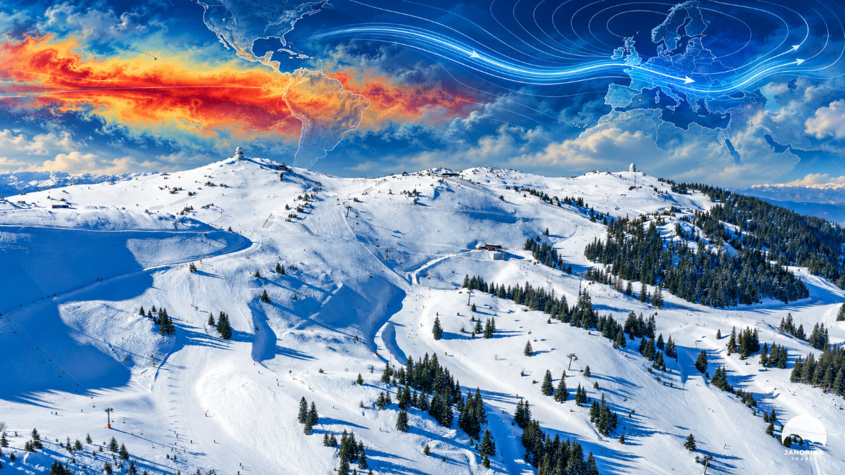
Planning to ski on Jahorina this winter? In September 2026, the tropical Pacific was warmer than at any time since measurements began. An ocean more than 10,000 kilometres away has therefore become the main topic for anyone planning a winter holiday. We looked at what the world’s leading weather institutions say and summed it up in five charts and two interactive maps: from a record-warm Pacific to a calendar showing when it is safest to come.
The answer is neither “winters like the old days” nor “the Balkans will have no snow”, as headlines like to put it. Seasonal forecasts give probabilities, not promises. This year, however, those probabilities say enough to plan a winter break more wisely.
In short:
- This autumn’s El Niño is one of the strongest on record.
- Models show a warmer, wetter winter for the Balkans, with about 12 cm less snow than average.
- At Jahorina’s altitude it is a different story: cold spells and snowmaking can make up for a slow start.
- December is the highest risk; late January and February are the safest choice.
1. The Pacific is warmer than ever: what NOAA says
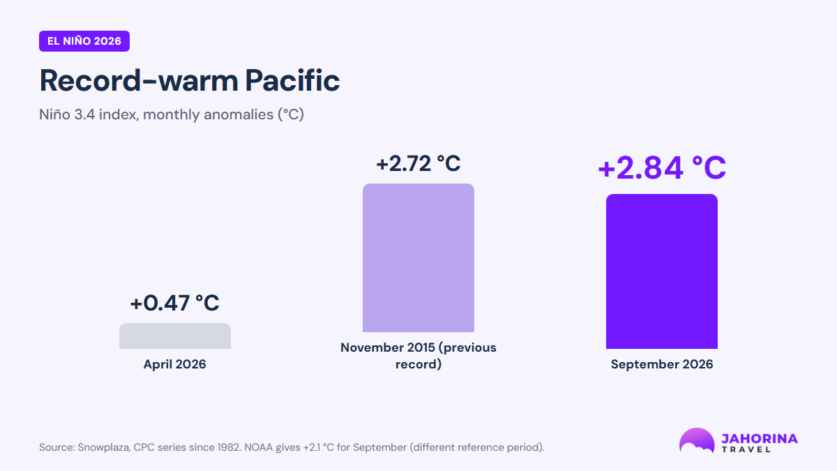
El Niño is a periodic warming of surface waters in the equatorial Pacific. It shifts tropical rainfall and, through it, atmospheric circulation across the Northern Hemisphere. According to data reported by Snowplaza, the Niño 3.4 index reached +2.84 °C in September, beating the previous record from November 2015 (+2.72 °C).
A small but important note: NOAA gives +2.1 °C for September. The difference is not an error; it comes from a different reference period in the calculation. Both figures say the same thing: this is one of the strongest El Niño events on record.
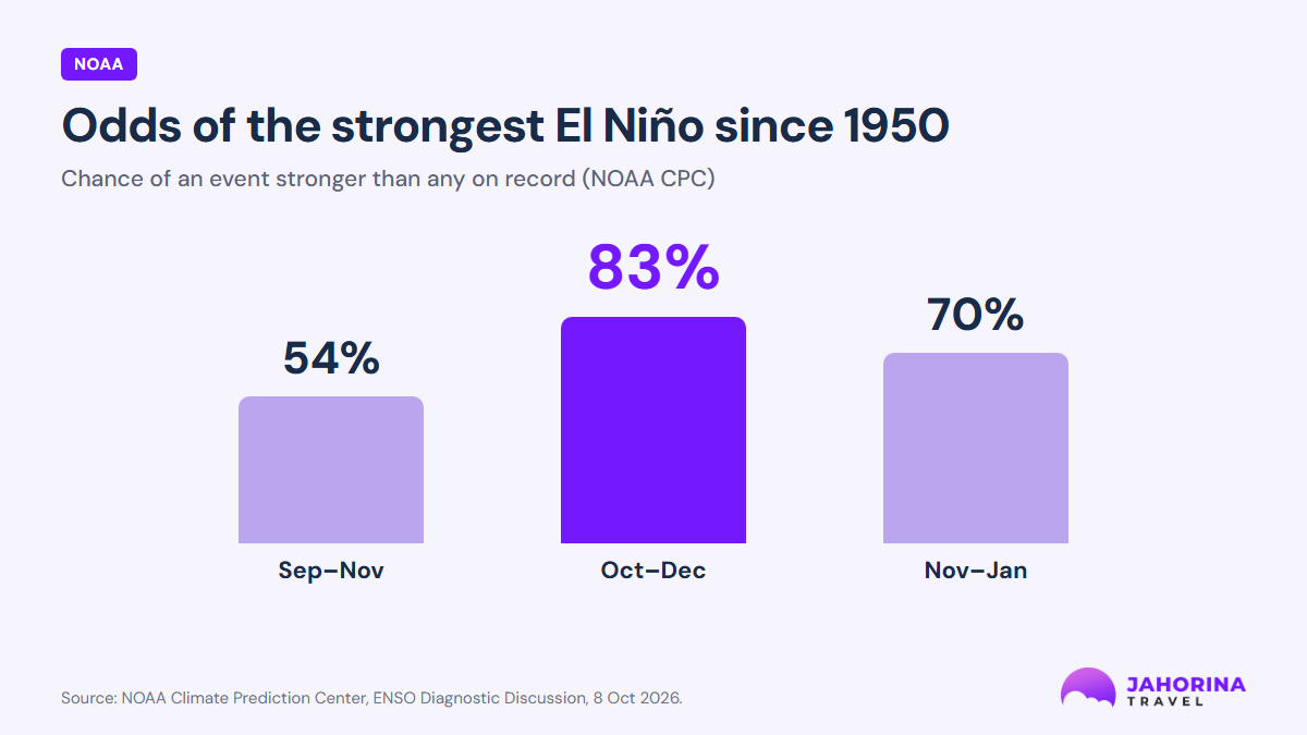
NOAA, 8 October 2026: El Niño will keep strengthening through the end of the year, with more than an 83% chance of staying strong to very strong until the end of winter (January–March 2027). The chance that this becomes the strongest El Niño since 1950 is 54% for September–November, 83% for October–December and 70% for November–January. NOAA adds that impacts are more likely with an event this strong, but not guaranteed.
2. How El Niño affects snow in the Balkans
El Niño does not create snow in the Balkans directly; it shifts the odds. Its influence here is weaker than in the Americas or Southeast Asia, because our weather is driven more strongly by the Atlantic and the Arctic. The influence reaches us in three steps:
- The tropics: warm Pacific water boosts rising air and showers over the central Pacific.
- Atmospheric waves: this disturbs the circulation and sends large waves across the Northern Hemisphere, shifting the jet stream over the Atlantic and Europe.
- The stratosphere: some of these waves reach high above the Arctic and can weaken the polar vortex. When the vortex is disrupted, cold air outbreaks from the north and northeast become more frequent a few weeks later.
The European Space Agency (ESA) has described exactly this chain and stressed that this “does not mean El Niño directly causes cold winters in Europe”; it only shifts the odds. Studies by Stefan Brönnimann of ETH Zürich show that past El Niño winters more often brought a negative North Atlantic Oscillation and colder late winters in northeastern Europe. The pattern does not repeat every season, however, and it is less pronounced in the strongest events.
For skiers, in practice: early winter more often brings a mild, moist southwesterly flow, rain in the lowlands and a high snow line. In the second half of winter the chances of shorter but heavier snowy spells increase.
3. What the models say: less snow in the Balkans
The Copernicus Climate Change Service (C3S) combines forecasts from several of the world’s leading weather centres. For winter 2026/27 it shows an increased likelihood of a warmer-than-average winter across almost all of Europe, and a wetter one across much of the continent. The average temperature anomaly for Europe is around +1 °C in December, January and February.
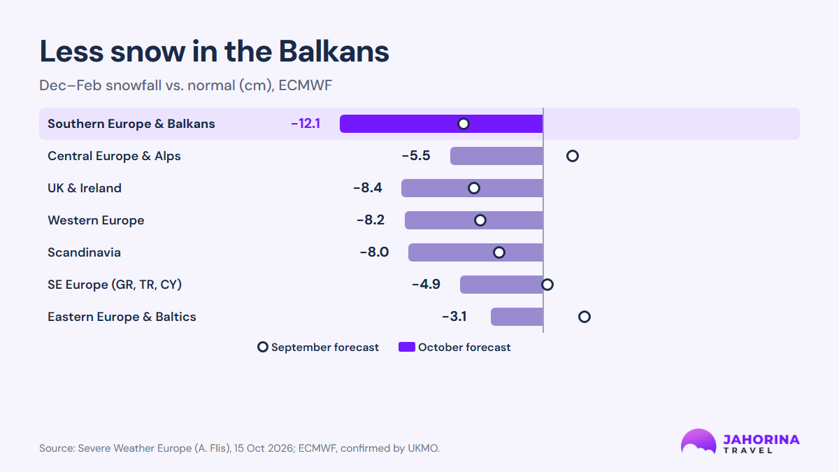
Andrej Flis, author of the Severe Weather Europe analysis, compared the September and October runs of the European ECMWF model. The result: every European region lost snow in the new forecast, and “Southern Europe and the Balkans” fell from −4.7 to −12.1 cm below average for December–February. That is one of the two largest downgrades on the continent. The UK Met Office model (UKMO) points the same way. December shows no clear snow signal anywhere in Europe, while February stands out with better snow chances in eastern and northeastern Europe.
How you read this matters. It is an average for a huge area, not a forecast for one mountain. The analysis itself stresses that seasonal models cannot predict individual snowstorms.
On the interactive map below, see where El Niño is and how, according to seasonal models, winds, rain and snow over Europe change from December to March:
El Niño and Europe's winter, month by month
How the Pacific reshapes winds, rain and snow over Europe
Mild and wet
A strong westerly and southwesterly flow brings mild, moist air from the Atlantic. Models show no snow signal anywhere in Europe; lowlands get rain.
Watch the polar vortex
The mild pattern continues, but ECMWF has raised the odds of a polar vortex disruption around late December and January. If it happens, cold air from the northeast can reach the Balkans a few weeks later.
The snowiest month
February shows the strongest snow signal, over east-central and northeastern Europe. For the Balkans, wintry spells are more likely now than at the start of the season.
Winter retreats north
The above-normal snow signal stays only in the far north. Elsewhere, higher mountains rely on the snow that fell earlier.
- Wetter than normal
- Snow signal above normal
- Possible cold air
Illustration based on Copernicus C3S, ECMWF and Severe Weather Europe seasonal forecasts (October 2026). Not a daily forecast.
4. Altitude decides
This is the most important chapter for anyone planning a ski trip. A warmer, wetter winter on average means more precipitation falls as rain in the lowlands. At altitude the picture is different. For the Alps, models expect a mild winter with a high snow line: good conditions are expected above roughly 1,800–2,000 m, with rain in the valleys.
Jahorina’s ski area spans about 1,300 to 1,916 metres. Pale lies in the valley, at about 850 metres. When a short cold spell arrives with a moist southwesterly flow, the upper mountain can get heavy snow within a few days, even if the seasonal average is below normal. At the same time, it may be raining in Pale.
Choose a month and see how the snow line shifts between Pale in the valley and the Jahorina ski area:
Pale and Jahorina through the winter
Choose a month and see where rain turns into snow
Highest risk
- Pale (valley)
- Mostly rain, snow does not last long.
- Jahorina (slopes)
- Natural snow only near the peaks; slopes rely mostly on artificial snow.
- Snowmaking
- Run whenever nights reach about −2 °C.
Uncertain
- Pale (valley)
- Rain and snow alternate.
- Jahorina (slopes)
- Snow on the upper slopes; a cold spell can bring a big snowfall.
- Snowmaking
- Keep building the base on cold nights.
Best chances
- Pale (valley)
- Snow is possible even in the valley.
- Jahorina (slopes)
- The strongest snow signal of the winter; the best odds for full slopes.
- Snowmaking
- Only top up where needed.
Depends on February
- Pale (valley)
- Snow melts quickly in the valley.
- Jahorina (slopes)
- Higher slopes usually hold snow until the end of the season.
- Snowmaking
- Mostly switched off.
Illustration of a likely scenario based on seasonal models (October 2026). The snow line is indicative, not a forecast.
5. Cold nights: the key to the season start
The start of the season on Jahorina today depends less on natural snow and more on how many nights are cold enough to run the snowmaking system. Snow guns work efficiently only when the air is cold and dry enough, roughly −2 °C or lower on the so-called “wet-bulb” temperature, which also accounts for humidity.
Last season started on 2 December and lasted 139 days, until 19 April, with more than 400,000 skiers. Snowmaking is crucial for such an early opening, because natural snow in early December is rarely enough for all slopes. In a warm, wet winter, those “windows” of cold become decisive: when two or three cold days come in a row, the slopes can be prepared quickly, even without much natural snow.
6. The wild card: the polar vortex
ECMWF has raised the odds of a polar vortex disruption in late December and January. According to analyses reported by Snowplaza, this happens more often than average in very strong El Niño winters. If it happens, cold air can reach the Balkans a few weeks later.
Researchers at the University of Reading, led by Dr Laura Baker, published in 2024 in Geophysical Research Letters that European winter forecasts are more reliable in strong El Niño years. They warned, however, that sudden disturbances high above the Arctic are exactly what models most often miss. That makes this winter a rare mix: the overall trend is clear, but a sudden reversal is still possible.
7. When to come: the winter 2026/27 calendar
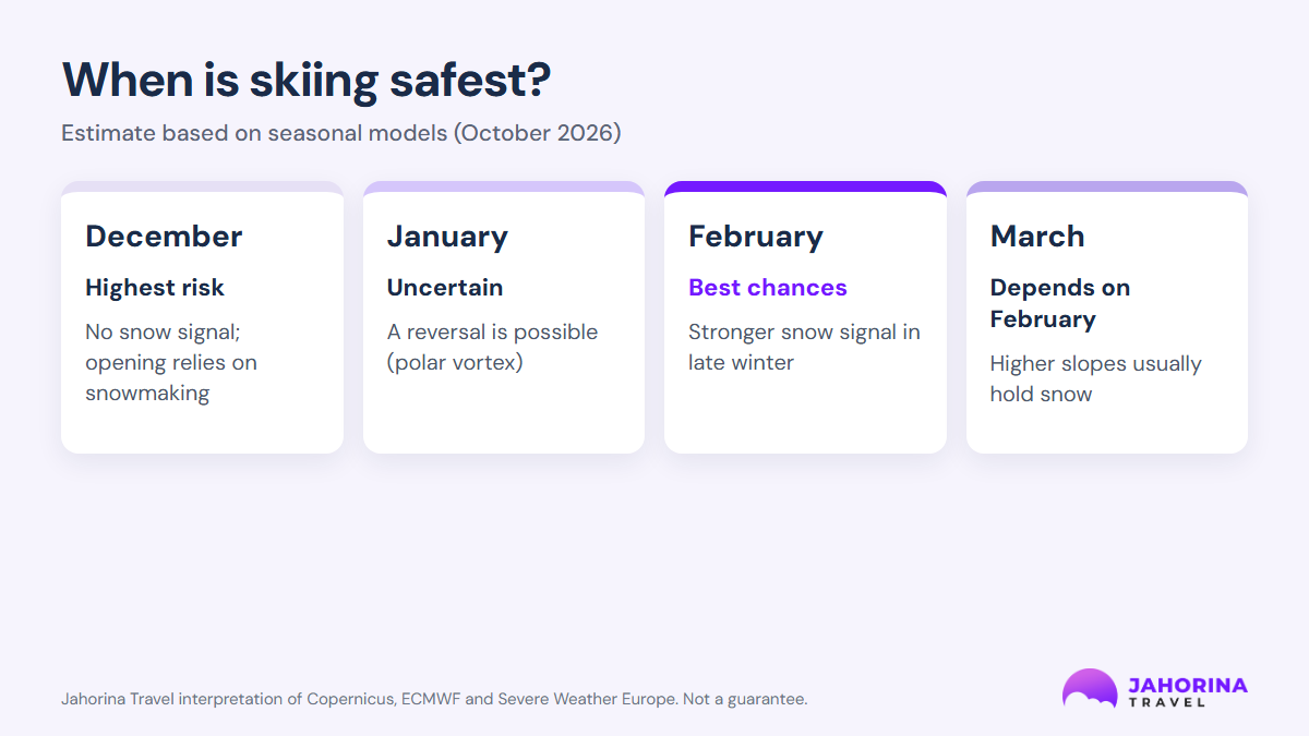
This is our interpretation of the seasonal models, not a guarantee:
- December: highest risk. Models show no clear snow signal. The season start will depend on how many cold nights allow snowmaking.
- January: uncertain. If the polar vortex is disrupted, this is when a reversal could arrive.
- February: best chances. The October forecasts show a stronger snow signal in the second half of winter.
- March: depends on February. Higher slopes usually hold snow for a long time.
What this means for your winter holiday
- December is the biggest gamble. For holiday dates, expect some slopes to rely on artificial snow and choose accommodation with flexible cancellation.
- Late January and February are the safest choice according to current models. This is also school holiday time, so book early.
- Buy a multi-day ski pass once snow is confirmed. Prices are in the OC Jahorina 2026/27 price list.
- Follow short-range forecasts, not seasonal ones. A 7–10 day forecast is reliable; a seasonal one only describes odds. Before you set off, check the weather forecast, live slope status and webcams.
- Have a plan B. If conditions are modest early in the season, Jahorina also offers trips in the surrounding area and activities that do not depend on deep snow cover.
Frequently asked questions
When will the first real snow fall on Jahorina this winter?
Seasonal models cannot predict the date of the first snowfall. They show that December this year looks weaker than average, with better chances in the second half of winter.
Does El Niño mean there will be no winter?
No. El Niño shifts the odds towards a warmer, wetter winter, but it does not rule out cold outbreaks. Above 1,500 metres, a wet winter can bring heavy, if shorter, snowy spells.
How does El Niño affect snow in the Balkans?
Through the jet stream and the polar vortex. Early in winter it more often brings mild, wet weather with rain in the lowlands; in the second half of winter the chances of cold outbreaks and snow increase. The effect is not the same every year.
When will the seasonal forecasts be updated?
NOAA publishes its next El Niño update on 12 November 2026, and Copernicus releases new seasonal charts at the start of every month. Jahorina Travel will follow every major update.
When are you planning to ski: December, January or February? Tell us in the comments or on our Facebook page.
Sources
- NOAA Climate Prediction Center, ENSO Diagnostic Discussion, 8 Oct 2026.
- Copernicus Climate Change Service, C3S multi-system seasonal forecast.
- Severe Weather Europe (A. Flis), Winter 2026/2027 Snowfall Forecast: October update, 15 Oct 2026.
- Snowplaza, Weather forecast winter 2026/2027, 8 Oct 2026.
- The Ski Standard, ESA on El Niño and cold-spell risk, 7 Sep 2026.
- Baker, L. H. et al. (2024), Geophysical Research Letters, 51, e2024GL108472 (University of Reading).
- Brönnimann, S., research on El Niño’s influence on European climate (wissenschaft.de).